

Winter Storm Warning
Areas Affected: Blue Earth; Faribault; Freeborn; Steele; Waseca
...WINTER STORM WARNING REMAINS IN EFFECT UNTIL 3 PM CST THIS AFTERNOON...
* WHAT...Heavy snow. Total snow accumulations of 5 to 8 inches.
* WHERE...Blue Earth, Waseca, Steele, Faribault and Freeborn Counties.
* WHEN...Until 3 PM CST this afternoon.
* IMPACTS...Plan on slippery road conditions. Patchy blowing snow could significantly reduce visibility. The hazardous conditions could impact the morning commute.
If you must travel, keep an extra flashlight, food, and water in your vehicle in case of an emergency. The latest road conditions for the state you are calling from can be obtained by calling 5 1 1. Road conditions can also be found at 511mn.org for Minnesota or 511wi.gov for Wisconsin.
Winter Storm Warning
Areas Affected: Bremer; Butler; Cerro Gordo; Franklin; Hardin; Worth
...Winter Storm Winding Down Across Iowa This Morning... .The winter storm affecting Iowa will gradually pull away from the state this morning with some light precipitation remaining through midday. While the heaviest precipitation has ended, some additional minor accumulations are anticipated along with snow packed roads impacting travel over most of the region this morning. ...WINTER STORM WARNING NOW IN EFFECT UNTIL NOON CST TODAY...
* WHAT...Portions of Northern and Northeast Iowa
* WHAT..Light snow with an additional accumulation of an inch possible.
* WHERE...Portions of central into north central Iowa.
* WHEN...Until noon CST today.
* ADDITIONAL DETAILS...Roads will remain snow covered and slick. Caution is advised while traveling through Iowa today and tonight. Side streets and country roads may take longer to clear, so please travel safely.
* IMPACTS...Plan on slippery road conditions. Patchy blowing snow could significantly reduce visibility. The hazardous conditions are expected to impact the morning commute.
If you must travel, keep an extra flashlight, food, and water in your vehicle in case of an emergency. For the latest travel conditions, check the Iowa 511 app, www.511ia.org, or dial 511.
Winter Storm Warning
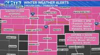
Areas Affected: Chickasaw; Floyd; Howard; Mitchell
...Accumulating Snow Continues For Parts of the Area... .Many areas saw accumulations of 4-7 inches of snow thus far, with the exception of southwest Wisconsin and adjacent northeast Iowa where 2-4 inches fell. Accumulating snow will continue near and west of a line from Eau Claire Wisconsin, to Preston Minnesota, to Charles City Iowa with 1 to 3 inches expected today. Lighter snowfall is expected to continue roughly along and north of the I-90 corridor with accumulations of an inch or less. Road conditions are expected to improve through the day with temperatures near freezing making road treatments effective. ...WINTER STORM WARNING NOW IN EFFECT UNTIL NOON CST TODAY...
* WHAT...Snow. 1 to 3 inches expected today. Snow diminishes this afternoon.
* WHERE...Portions of north central and northeast Iowa and southeast Minnesota.
* WHEN...Until noon CST today.
* IMPACTS...Plan on slippery road conditions.
If you must travel, keep an extra flashlight, food, and water in your vehicle in case of an emergency. In Iowa, visit 511ia.org for road conditions. In Minnesota, visit 511mn.org for road conditions.
Winter Storm Warning
Areas Affected: Dakota; Goodhue; Washington
...WINTER STORM WARNING REMAINS IN EFFECT UNTIL 3 PM CST THIS AFTERNOON...
* WHAT...Heavy snow. Total snow accumulations of 5 to 7 inches.
* WHERE...Portions of east central and southeast Minnesota and west central Wisconsin.
* WHEN...Until 3 PM CST this afternoon.
* IMPACTS...Plan on slippery road conditions. The hazardous conditions could impact the morning commute.
If you must travel, keep an extra flashlight, food, and water in your vehicle in case of an emergency. The latest road conditions for the state you are calling from can be obtained by calling 5 1 1. Road conditions can also be found at 511mn.org for Minnesota or 511wi.gov for Wisconsin.
Winter Storm Warning
Areas Affected: Dodge; Olmsted; Wabasha; Winona
...Accumulating Snow Continues For Parts of the Area... .Many areas saw accumulations of 4-7 inches of snow thus far, with the exception of southwest Wisconsin and adjacent northeast Iowa where 2-4 inches fell. Accumulating snow will continue near and west of a line from Eau Claire Wisconsin, to Preston Minnesota, to Charles City Iowa with 1 to 3 inches expected today. Lighter snowfall is expected to continue roughly along and north of the I-90 corridor with accumulations of an inch or less. Road conditions are expected to improve through the day with temperatures near freezing making road treatments effective. ...WINTER STORM WARNING REMAINS IN EFFECT UNTIL 3 PM CST THIS AFTERNOON...
* WHAT...Snow. Additional snow accumulations of up to one inch today. 1 to 3 inches expected along a Wabasha to Preston line.
* WHERE...Portions of southeast Minnesota and central and west central Wisconsin.
* WHEN...Until 3 PM CST this afternoon.
* IMPACTS...Plan on slippery road conditions.
If you must travel, keep an extra flashlight, food, and water in your vehicle in case of an emergency. In Minnesota, visit 511mn.org for road conditions. In Wisconsin, visit 511wi.gov for road conditions.
Winter Storm Warning
Areas Affected: Fillmore; Mower
...Accumulating Snow Continues For Parts of the Area... .Many areas saw accumulations of 4-7 inches of snow thus far, with the exception of southwest Wisconsin and adjacent northeast Iowa where 2-4 inches fell. Accumulating snow will continue near and west of a line from Eau Claire Wisconsin, to Preston Minnesota, to Charles City Iowa with 1 to 3 inches expected today. Lighter snowfall is expected to continue roughly along and north of the I-90 corridor with accumulations of an inch or less. Road conditions are expected to improve through the day with temperatures near freezing making road treatments effective. ...WINTER STORM WARNING NOW IN EFFECT UNTIL NOON CST TODAY...
* WHAT...Snow. 1 to 3 inches expected today. Snow diminishes this afternoon.
* WHERE...Portions of north central and northeast Iowa and southeast Minnesota.
* WHEN...Until noon CST today.
* IMPACTS...Plan on slippery road conditions.


